23주 - Jeju Island - Part 2

by - 12:42

Day 3.
I had breakfast at the guesthouse and checked out to head over to Jusungolli cliffs (주상절리). The rain let up shortly after I arrived and it cleared up to be a beautiful day.

The cliffs are made up of hexagon-shaped pillars which look like they were intentionally carved but were actually formed by the hot lava meeting the cool ocean water.
I made my way along the coastal road, which was almost a mistake because I found myself pulling off to the side of the road literally every half mile to get out and take pictures. If I drove the coastal road around the entire island the trip probably would have taken me three times longer than necessary with all my stops. I was headed to Songaksan (송악산), which is in the distance in this picture:
Above is Sangbang-san from a ways down the coast and below is Hyungjae Islands.
I took /so many/ pictures of Sangbang-san. It's just so picturesque!
As I was walking up Songak-san I came across some cave trenches - these were built by the Japanese military towards the end of the Pacific War, when the Japanese were fortifying Jeju-do as their last line of defense. They were actually open and I saw a guy walk in one, but that is not for me.
After getting thoroughly sunburnt, I left Sangaksan and drove along the coastal road all the way up the west coast of Jeju-do. Again, the views up the coast were so stunning I kept stopping to take pictures. I spent a lot of time just watching the waves hit the rocks and had a few short conversations with other people who were stopping along the coast. I had ajusshis ask me if I'm from England and Australia, which was surprising because I don't have the accent for either.
I finally made it up the west coast to Hyeopjae beach (협재해변), which is famous for its white sand beaches and views of nearby Biyang Island (비양도). The main beach was really crowded, so I walked down the coast a bit to a less crowded area and spent a few hours swimming.
After a few hours at Hyeopjae beach some ominous clouds started rolling in so I got back in my car and continued up to Gwakji Gwamul beach (곽지과물해변). I was hoping to catch the sunset but that didn't happen with the clouds.
Statues of haenyeo (해녀) can be found throughout the island. Haenyeo literally translates to "sea women," the name for the female divers of Jeju-do. In the 1700s, sea-diving became a female-dominated industry and many women replaced their husbands as the breadwinner for the family. Diving is a strenuous and dangerous job, so haenyeo are known for their spirit and resiliency. Since the work of divers has been largely industrialized there are few haenyeo still around today. However, there were several places along the coast where I saw groups of them sitting on a blanket along the rocks, underneath a canopy, selling their fresh catches.
My last stop for the day was Yongduam (용두암), or Dragon Head Rock, which is on the northern coast in Jeju City. Yongduam is a basalt rock formation which is shaped like the head of a dragon. There are several tales about how Yongduam came to be, but my favorite is that it's the remains of Yimugi, the Dragon King's messenger who was sent on a mission to steal a precious jewel from Mount Halla. The god of Mount Halla heard about the mission and as soon as Yimugi rose out of the water the god of Mount Halla shot an arrow through the dragon's heart. Yimugi plunged back into the ocean, but his head and several parts of his body remained above and water and turned to stone.
After a quick visit to Yongduam I went to my hostel in Jeju City. There was no one at the desk when I arrived, only a note with a phone number on it, so I had to call the number and tell them I was there and needed to check in. I'm terrified of talking on the phone in Korean, so I was super proud of myself and the fact that the guy understood me. I had booked a room in a 4-person dorm, but it was a random Wednesday night and the hostel wasn't busy so I ended up having the room to myself. Not bad for about $15 for the night.
Day 4.
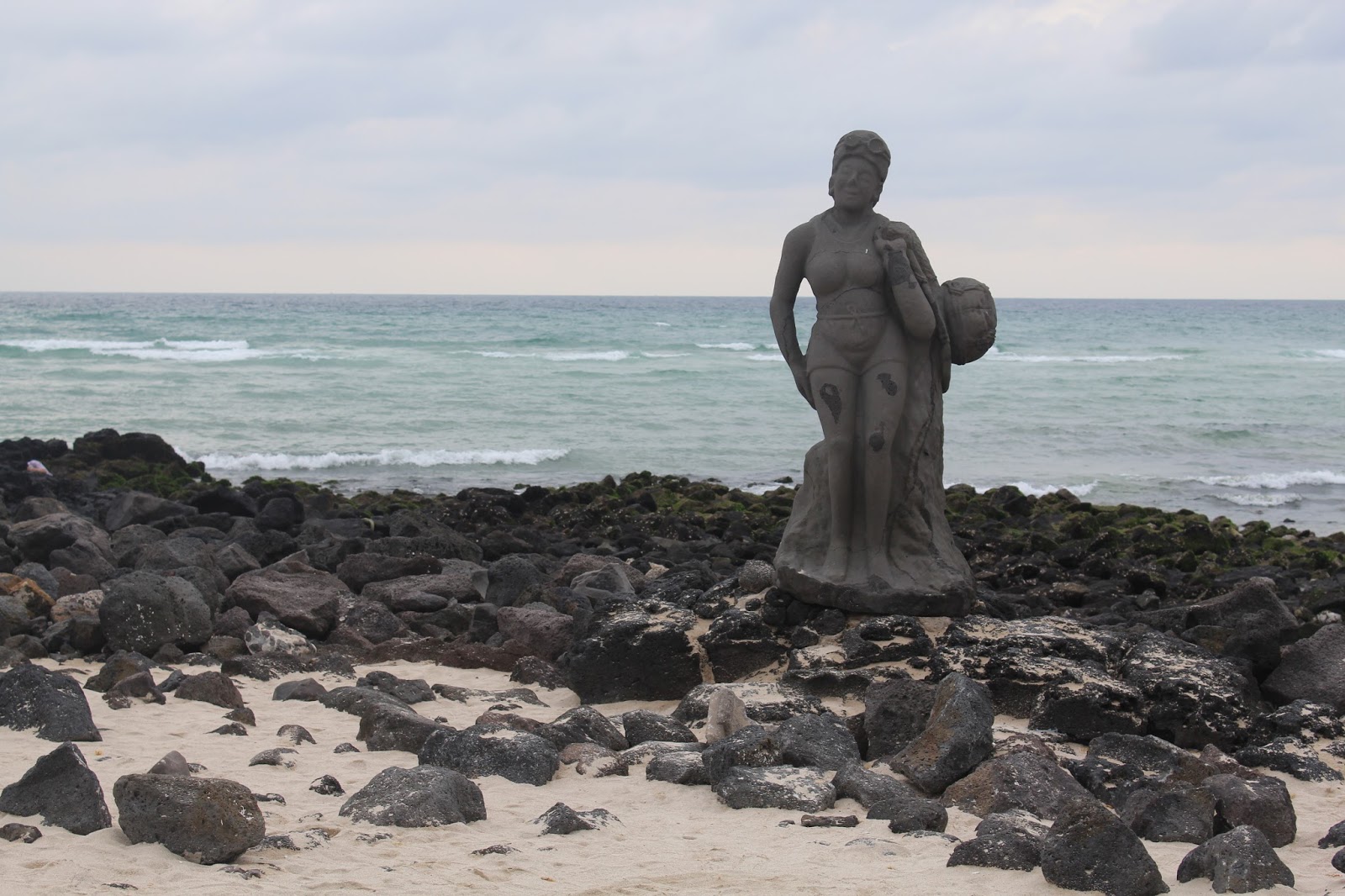
My first stop for the day was Loveland (러브랜드), which was about 30 minutes inland. Loveland is famous for being an "erotic theme park" with about 140 sculptures. It was... interesting. Honestly, I was a bit disappointed. It was the most expensive and least impressive thing I saw on the island. The park opened in 2004, and it seemed to me that it's never been updated since it opened. Everything looked kind of run-down. There were speakers throughout the park, and as soon as I got there Colors of the Wind from Pocahontas started playing. I was more excited about that than anything else. My favorite sculpture, by far, was the woman below.
I drove back up to the coast to Hamdeok Seoubong beach (함덕 서우봉해변), known for its clean, emerald-blue water. The water was beautiful, and it stays shallow really far out so it's great for kayaking and snorkeling. I wasn't planning on staying at this beach for long, so I didn't partake in either. I got a smoothie and walked along the shore for a bit before heading to my next destination.
I decided to escape the afternoon heat by heading underground, into the Manjanggul lava tube (만장굴). The lava tube is almost 8km long, but only 1km is open to the public. At the end of the kilometer walk through the tube was a 7.6-meter-tall lava column, which is the largest known lava column in the world. I tried to get some good pictures of the rock formations despite the low lighting.
I continued inland to Daheeyeon Gardens (다희연). The most popular activity here was apparently zip lining, with lots of people signing waivers and getting harnessed up to start a zip line course all across the green tea fields. I walked through the gardens before going back underground where there was a cafe in a cave. I'm not sure how that works out, because I'm pretty sure there are also bats down in that cave, but it was cool.
I drove back to the coast to Woljeongri beach (월정리해변), known for its white sand, emerald-blue water, and the wind turbines in the distance. Apparently a lot of people think the turbines are an eye-sore, but I kind of like them. I feel like it adds character or something. There were a lot of beach-front shops and restaurants. After circling around for a while to find a parking spot, I got a black pork taco from a Korean-ized Mexican restaurant. Jeju-do is famous for its black pork, but I didn't want to go to Korean BBQ by myself so at least I can say I did eat black pork in taco form while I was there.
I continued along the coastal road to Hado beach (하도해수욕장), where I spent a few hours swimming. Hado beach is one of the quieter beaches on the island and isn't visited much by tourists. I swam around for a while and checked out Udo Island in the distance. Udo is only about a 15-minute ferry ride away, but I decided I'd rather spend the afternoon on the beach than walking around Udo.
My last stop for the day was Gwangchigi beach (광치기해변) on the west coast of Jeju-do, which isn't really the beach to go to for swimming. There is a black sand beach, but once you get to the water it's just rock. This beach gives a great view of Seongsan Ilchulbong, which I wanted to see before I hiked it the next morning.
I finally made it to my hotel just a few blocks away, watched the sunset from my hotel room balcony, and showered before going out again in search of dinner.
Day 5.
My last day on Jeju-do.
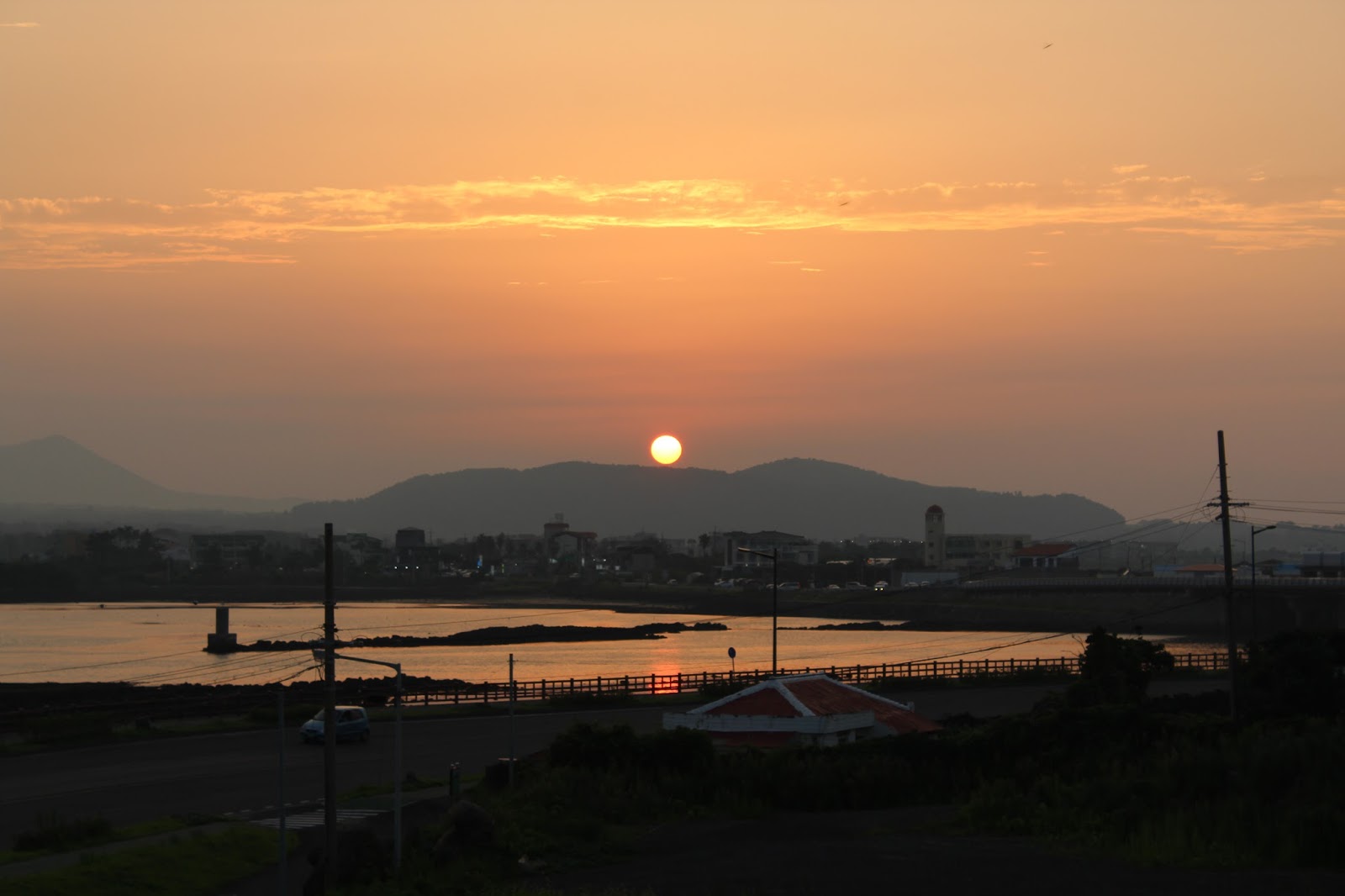
I woke up at 4:45am to make it to the top of Seongsan Ilchulbong (성산일출봉), or Sunrise Peak, in time for the 5:51 sunrise. There were steps. So. Many. Steps. I witnessed one girl give up less than halfway up. Somehow, I made it. I think. I don't remember much of the hike, to be honest. All I know is that by the time I reached the top of that mountain, I was the sweatiest foreigner on the entire island.

There's a large rock standing tall about midway up to the peak. This is Deunggyeongdol, or Lamp Rock. As I passed by I bowed twice in honor of Seolmundae, the creator of Jeju. She used this rock as her lamp to work by night as she built Mount Halla.
Gwakchigi beach as seen from the top of Seongsan Ilchulbong. All of those mounds rising up from the fog are oreum.
There was an audible gasp from the crowd at the top of the peak as a sliver of the sun came up over the horizon. It was really amazing. There's about to be a lot of pictures of the sunrise  - I'm rarely awake early enough to see a sunrise, so I took a lot of pictures to remember this one.
Down in this cove is a haenyeo house - it was also advertised that there are haenyeo shows here in the afternoon, where you can watch the women divers bring in their catch.
I spent almost 2 hours at Seongsan Ilchulbong before walking back to my hotel, showering, and checking out. Next stop was Seopjikoji (섭지코지). There's a path along the coastline leading out to a lighthouse with great views of Seongsan Ilchulbong. It's a popular area because several TV dramas have been filmed here.
I was drinking Jeju sparkling orange drink while walking along the path. Living the dream, basically. Jeju-do is famous for its oranges and tangerines - hallabong (한라봉) and gamgyul (감귤), respectively. Hallabong have a bump on the top which resembles Mount Halla. You can kind of see it on the can. I had so many orange smoothies during my trip.
I continued the last stretch of my loop around the island, stopping in the southeast corner of Jeju-do at Pyoseon Haevichi beach (표선해비치해변). This beach is huge. Like, really huge. It was high tide when I was there, but when the tide is out this entire area is just sand. While the tide was in, it was a shallow expanse of water that you could easily wade far out into.
I only spent about an hour at Pyoseon beach before I had to get back on the road. I took a brief, unplanned detour when I saw a sign for Seolmundaehalmang (설문대할망), which I believe is an area that honors goddess Seolmundae. I followed the sign off the main road, but there were no more signs beyond that to follow. I tried looking it up on my GPS, but the only thing that was coming up as a result was Seolmundaehalmang Theme Park. I followed the directions to that and was taken down an overgrown road where there was another sign indicating that I was in the right place, but the small gravel parking lot was chained off and the area looked abandoned. I didn't want to get lost in the woods looking for this place and miss my flight, so I continued on to Seogwipo.
I brought my journey full-circle by returning to Oedolgae as my last stop on the trip. When I was here earlier in the week the rain was moving in, but this time the sun was out at the water looked stunning. There was a section of fencing that was down so I actually skipped that and went out onto the cliffs for these photos.
I bought some last-minute souvenirs from the vendors set up near Oedolgae and was off to the airport to go home. On the way down to Seogwipo on day 1, I drove down the 1118 on the east side of Halla-san, so on way back to the airport I took the 1139 on the west side of Halla. I basically did an inner circle and an outer circle of the island - I feel pretty accomplished with how much of the island I managed to see in 5 days. And yet I was sad to leave.
There were some rain clouds over Seoul as we landed, forming a double rainbow for a few moments.
The south side of Seoul - the tall silver building just under the wing is Lotte World Tower, where I saw the fireworks show a few months ago.
Namsan Tower on the mountain in the distance with the 63 building on the near side of the Han River.

You May Also Like

1 comments

  1. Totally enjoyed the pictures and your narrating. You are just so darn cute. But we ARE going to discuss that X rated place you visited, NICOLE ELIZABETH!!! Hope you kept your eyes closed thru most of it. (LOL).
    LOVE YOU.

    ReplyDelete